January 15, 2023
As predicted, it started blowing Friday night, and it didn’t relent until this morning. 36 hours of gray skies, dark waves, and a cold, gale-force wind. There were even waves inside the harbor, and the boats were rocking. But everyone was tied securely, and there were no problems.
Today seems very different – we are returning to normal. The clouds are white, the sky is blue, and the sun is warming everything up. We had expected to leave today, but it’s now apparent that sea conditions will keep us here until Wednesday. Oh no! Three days by the pool. Or the beach. Drat.
For those of you who know Lynn, you know that she is an avid learner. If she’s involved in something, she wants to master it. Her new focus is weather forecasts, and I’m glad to have her involvement, because they often require interpretation and agreement on our indicated action. I’m happy to make these decisions on my own as Skipper, but I’m happier to do it with Lynn’s involvement.
We have a half-dozen weather apps on our phones, and we subscribe to two additional services that arrive by email each morning. We understand that ALL of them begin with the NOAA forecast, and then they fold in local data like reports from weather buoys.
Why do we look at so many? Because each differs slightly, and we are learning which ones prove to be more trustworthy and more intuitive to use.
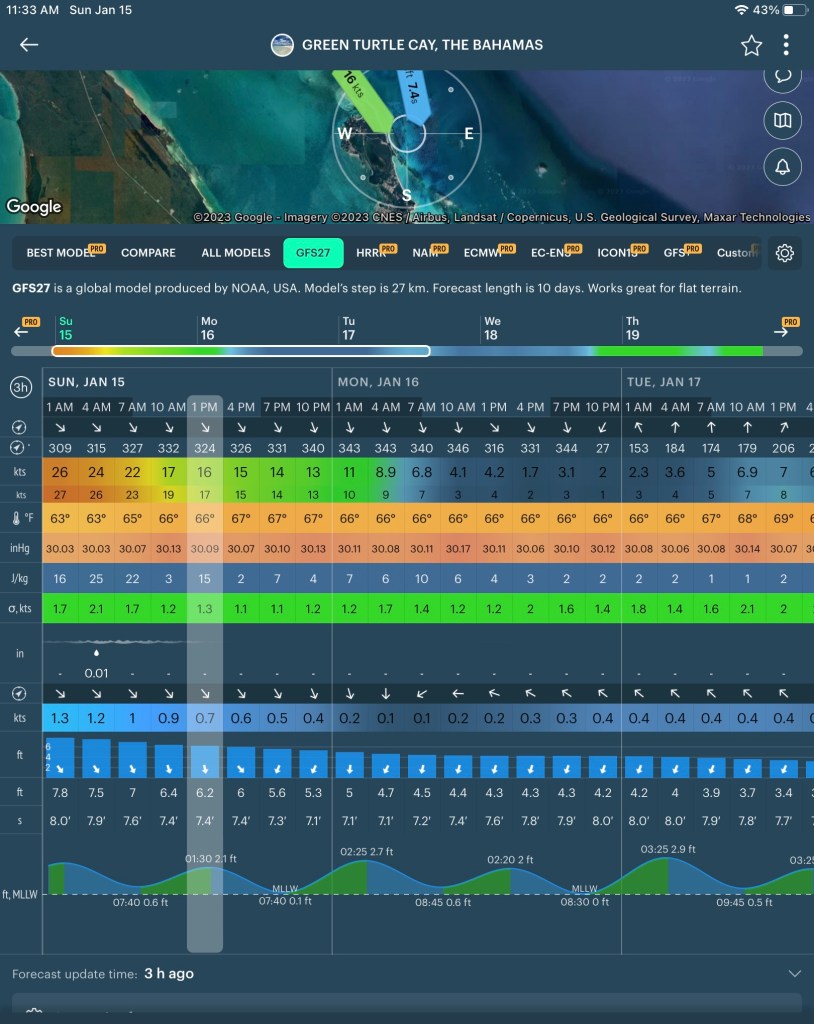
Here’s one example of the Windy app with tons of data. The wind direction and speed are towards the top, and the wave direction and height ar towards the bottom along with the tides. The winds drop from 26 mph to just over 5 but the waves only drop from over 7 feet to around 5feet and stay for the next two days. On Wednesday they drop to 2 feet which is where we are comfortable. We can scroll ahead five days on this app.
While this tabular data is very helpful, one of the reasons that we enrolled in the Chris Parker subscription forecast is that it offers more locally-specific and Bessel specific info: He takes the meta forecast; “A cold front is approaching from the west”, and he explains the local effect: “This will produce a line of dangerous squalls across the Central Bahamas from Friday evening to Sunday morning.” He also offers more direct advice on what to do or not to do: “All vessels should plan to be in port by Friday afternoon.” OK, that’s clear enough!
So, while we have been pinned down by the wind, we’ve been studying the forecasts and talking to the other boaters here on the dock. And the consensus is clear: while the winds diminish today, Monday, and Tuesday, the seas don’t calm down until Wednesday. Prior to that, they are still running 4-5 feet. That wave activity, and the direction they are running, creates a “Rage” condition in the Whale Cay Channel.
We had come to that conclusion on our own, but it is reassuring to have other skippers voice the same opinion.
TTFN. We are off to the beach. Or pool!

Rod,
How did you get so lucky to find Lynn.
You better be the perfect man. Can’t
wait to meet her. Judy
LikeLike