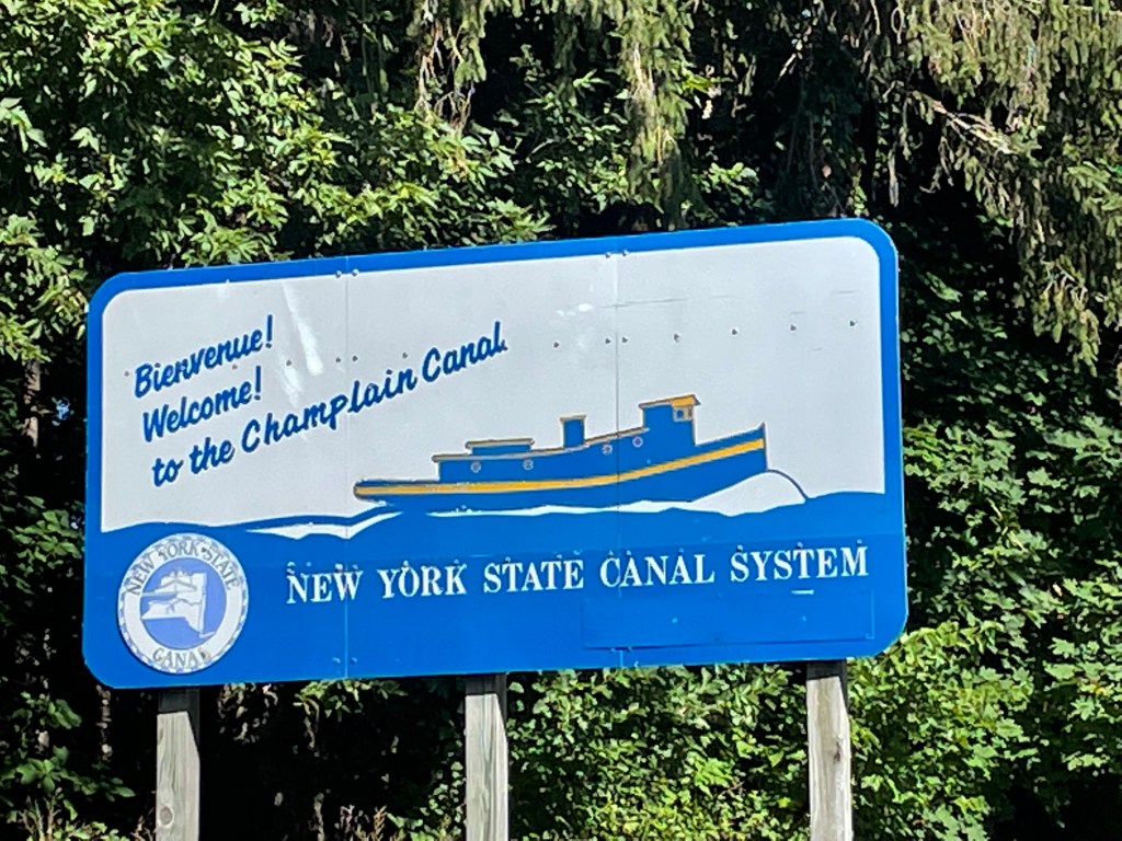
The Champlain Canal – 2

August 4, 2022

We traversed five more locks today – all routine.  We were still in the Hudson River for about half the day – the second half was canal.  Both are narrow, with trees on each side.  Very bucolic.  There are two principal differences between the river sections and the canal sections:

• The river curves; the canal is fairly straight

• The speed limit is 10 mph in the canal

The Canal was scenic with the mountains (Vermont) in the distance.  We knew there were restricted speeds and a number of locks, so we planned to go just 35 miles today. 

We moseyed along at 10mph, and guess what?  We got there just the same.

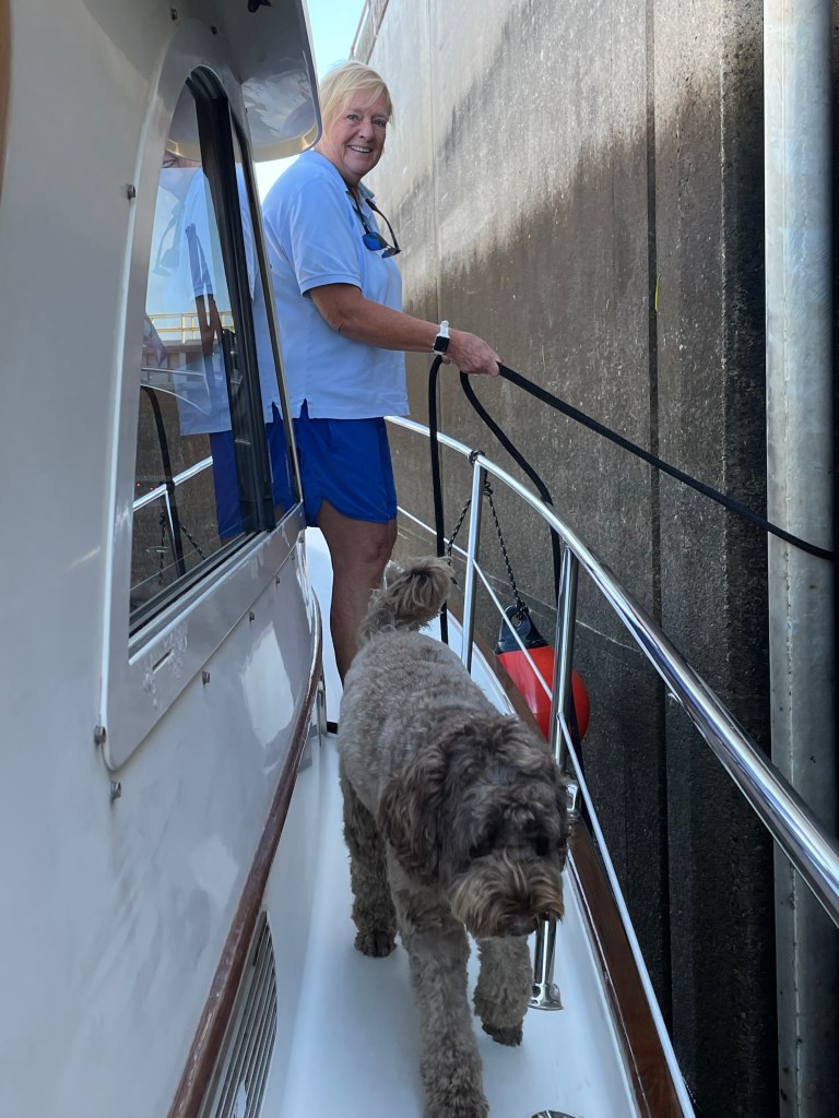
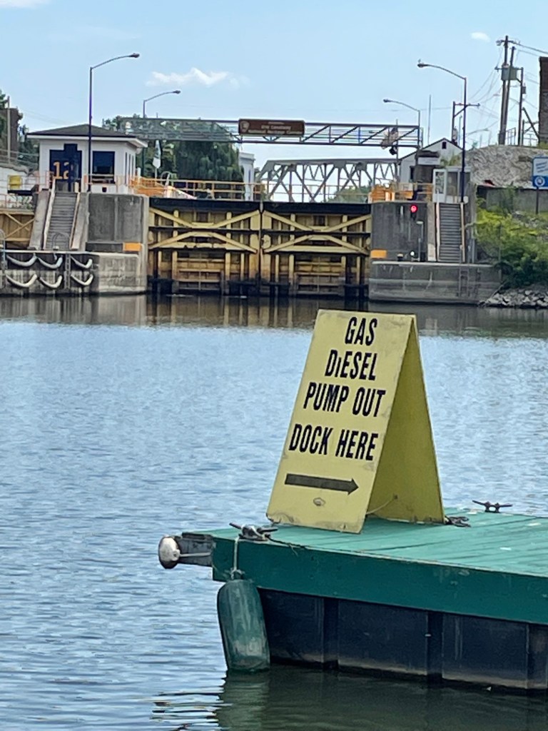
Here’s a photo of Lock #12 – the final lock in the Canal.  We are all the way through and tied up for the day.  It’s expected to hit 99 degrees today, but we are plugged in and air conditioned!

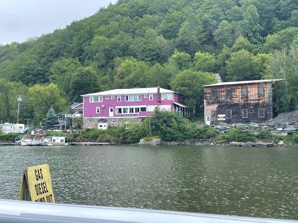
This appears to be a rather impecunious part of the world, and there are no restaurants as far as we know, so we’ll eat aboard: hot dogs and beans – one of my faves!  Lynn deserves accolades for planning all the food so carefully.

Not the most scenic view from the boat!

Tomorrow, we run from here to Burlington – roughly 70 miles.  From what I recall, Burlington is quite attractive and sophisticated; it will provide quite a contrast with tonight’s humble setting.

The Champlain Canal – Day One.   

August 3, 2020

Today we passed through 5 locks, raising us a total of 82 feet.  We left shortly after 7 AM, and we tied up at 2:30.  A long day.  Not particularly difficult, but made somewhat longer by lock procedures:

• The first lock is called Federal Lock, and it is located at Troy NY, right where the Hudson ceases to be navigable.  We had to wait about 20 minutes while they discharged a southbound boat that was already in the lock chamber.

• Right after the Federal Lock, you turn left for the Erie Canal or straight for the Champlain Canal.

• Next is C-1 (for Champlain 1).  New this year (and unbeknownst to us, C-1 now accepts northbound boats only every two hours (on the odd hour).  We arrived at 10 and waited until 11. C-1 is also now “double-flushing (they raise the water level, drop it and raise it again) in an attempt to prevent the spread of the Round Goby, an invasive species.  So once we got into C-1, it took 30 minutes, instead of 15.

• C-2 is also double-flushing.

• From there on, it got a lot easier, as each lockkeeper called ahead to tell the next lock that we were coming.  So we usually had a green light to enter as soon as we arrived, and C-3 and C-4 took just 15 minutes apiece.

The procedure itself is pretty simple:

• We set fenders and a mid-cleat line on the starboard side.

• I drive the boat into the lock.

• Lynn stands on the starboard side-deck, holding the line.

• The lock chamber has long “pipes” that run vertically.  These are located every 50 feet or so.

• I line the boat up so that Lynn can slip the line behind (around) the “pipe”.

• As the water rises, she holds the boat in position by slipping the rope up the pipe.

• Despite some initial apprehension, Lynn reports that “It was fun!”

Guiness helped!

We covered just 45 miles today, and I am so glad I didn’t plan on more.  I believe I planned appropriately for the impact of the locks.  And because I did, we never felt worried about how long it was taking.  Anyway, now we are fueled, and pumped out, and tied up in Schuylersville, NY, which Lynn tells me has a lot of good restaurants.  Who knew?

Tomorrow, I am planning to cover just 35 miles, because we have 5 locks and more reduced speed zones in the canal.   That will put us in Whitehall, NY, just at the southern tip of Lake Champlain.

TTFN

R&L&G

The Hudson River – Day 2

Tuesday, August 2, 2022

First, an additional note about Newburgh.  We had posted the blog before we went to dinner, and as we waited for our table, we met a woman and her son who knew the Drennen family – Cathy’s relatives.  And they bought us a round of drinks.  Irish hospitality!

View this morning looking South

Again, today, a very pleasant run up the Hudson.  I have never cruised anywhere quite like this…towering granite cliffs and hills on either side, the water almost 200 feet deep in spots like West Point.  Picturesque old lighthouses along the way.

Notice the Catskills mountains in the background

And this river just goes ON and ON and ON.  We are two days into the trip up the Hudson (about 120 miles under our keel) and still not at the end.

We truly felt some appreciation for what the early explorers must have experienced, as they pushed up this massive body of water, searching for a Northwest Passage to the Orient.

About halfway into today’s trip, the Catskill Mountains appeared on the horizon, dwarfing the cliffs beside the river.  I mistakenly thought that we were already seeing the mountains surrounding Lake Champlain, but of course, we are days away from that.  That being said, the Catskills are VERY impressive from this perspective!

Crossing under the “Rip Van Winkle Bridge”

We are now tied up at Donovan’s Shady Harbor Marina in New Baltimore NY.  Tomorrow morning, we’ll run the final 20-mile leg, past Albany to Troy, where we’ll enter the first lock.

Yowza

Newburgh

Monday – August 1

We’ll get to Newburgh in a minute. But first a final note about Liberty Park, where the Liberty Landing Marina is located. As you approached the Hudson River on foot from the New Jersey side, there is a spectacular 9/11 Memorial, titled Empty Sky. Two towering aluminum monoliths direct your gaze across the river to where the twin towers once stood. As you walk between the aluminum panels, they are etched with the names of all the New Jersey residents who died when the twin towers fell. And when you reach the end of your walk, your gaze is centered on the new World Trade Center. It is beautifully understated and surprisingly powerful.


OK, Now back to our regularly scheduled programming:

We had a perfect trip up the Hudson River this morning: flat sees with the wind and tide at our back.

Leaving Manhattan under the GW bridge at 179th Street (notice the old lighthouse)


It’s no wonder that the early explorers marveled at the Hudson River: it is wide, and it is 100 feet deep, and the area called the Hudson highlands is spectacular, with high granite cliffs on both sides and towering up-thrusts like Storm King Mountain and Bear Mountain.  And of course, West Point, which, unfortunately, is rather ugly from the water. 

The Cliffs of New Jersey
West Point

Now we’re docked in Newburgh, just in the shadow of the Newburgh-Beacon Bridge. 

I have been to Newburgh several times before; my late wife Cathy had family here. But I never really put it into its context on the Hudson. The vistas looking south really are remarkable.


Nothing exciting planned for tonight; a boring meal in a boring restaurant, but today was a very scenic ride.

Tomorrow: one more day on the upper Hudson; then we enter the Champlain canal on Wednesday.

ttfn

R&L&G


NYC

Sunday, July 31, 2022

We spent an hour or so this morning planning our trip through NY Harbor (scheduled for Monday).  Lynn had some reservations about cutting through the Harlem River to Spuyten Duyvil, so we decided we would go back around the tip of Manhattan, and then head up the Hudson River.

Our destination today was to be Oyster Bay, but we pulled out of Port Jefferson this morning onto a Long Island Sound nearly as smooth as glass.  A glorious day: sunshine, no traffic, and no swells.  Smooth sailing!  Here’s a shot as we approached the Throg’s Neck Bridge, at the mouth of the East River.

The vertical support reflection shows how calm the water was l

Wait a minute!  The East River?  You thought we were going to Oyster Bay, didn’t you?  Well, here’s what happened…

Although we left late, (9AM), we were abeam of Oyster Bay by 10:30, and we realized that we could shave some time off Monday’s trip by going farther today.  So we cancelled Oyster Bay and booked a slip at Liberty Landing, just across the harbor from Manhattan.

From the stern the UN and Empire State Building

As usual, the trip down the East River was fun…with lots of urban scenery.  Now, we are docked at Liberty Landing, with stunning views of Lower Manhattan.

Lower Manhattan


At the marina

Tomorrow, we start an exciting new phase – heading up the Hudson River!

ttfn

R&L&G

PORT JEFFERSON, NY

SATURDAY, JULY 30, 2022

A gorgeous trip today: blue skies, calm seas, riding the inbound tide eastward into Long Island Sound.  We ran along Long Island’s north shore, past towering sand cliffs and rocky promontories.

Rocky Point – wonder how it got its name!

Port Jeff is a HUGE harbor, miles long and miles across, surrounded by undeveloped beaches.  

We are staying at the Port Jefferson Yacht Club.  I’m not sure about the club facilities in general, but the dock crew is pathetic.  Good thing we can handle ourselves.  

Today, we had to walk about 25 minutes to re-provision the boat.  And wash her down from all the salt spray.  There is really quite a lot of work behind this pleasure cruise.

Tonight, we’re dining at Danford’s, the next-door marina.  Next time, I’ll dock there as well.

BTW, we had a response regarding my post about how I repaired the water pump by rapping it with the flashlight.  Phil, a former TWA pilot, and a friend of ours at Hershey’s Mill, wrote to say that “In the airlines industry, this is known as ‘malletizing’”.   LOL

SAG HARBOR, NY

Friday   July 29, 2022

Hi, this is Lynn posting tonight from Sag Harbor.  

As we were finishing dinner on the boat last night (at Pt. Judith), we watched the fog roll in. Visibility dropped to less than 50 feet; we could hardly see the bow of our own boat!  

Point Judith is a major fishing harbor with a very narrow entry channel, and I was concerned how we would get out in the morning. Radar picks up everything, moving and stable, and in a no-wake area it might be hard to tell the difference. And I doubt that many of the small craft even have radar. So I was very concerned about the risk of collision, even at low speed.

Luckily, we woke up to clear skies and sun and flat seas.  Rod said he had never seen a fog lift like that – it usually takes until almost 11:00 to burn off.  This one just evaporated. We left the dock early to catch the tide; after leaving the dock at 6:20, we were out in the sound by 6:40 running with the wind and tide at 19 mph. By 7:00 Rod had us on autopilot and was reading. 

The seas were flat as a lake – so far a perfect day. With one exception. The water pump on board is acting up. The one that provides water for washing and flushing and showering.  The tank is full, and the filters and pump have been checked. Intermittent water yesterday and this morning, nothing. It’s always something.

Anyway, we had a spectacular trip over to Sag Harbor; we arrived so early that we could not get into our slip.  So we took an hour to circumnavigate Shelter Island, a lovely little bit of heaven sequestered between the forks of Long Island.

Sag Harbor itself is a charming little town on the north side of the south fork of Long Island.  Got it?  Surprisingly, like Nantucket, it has a fierce whaling history.  

We had time for a stroll around town, and we got to photograph Billy Joel’s house!  

BONUS!  Rod fixed the water pump by hitting it with a flashlight!

POINT JUDITH HARBOR OF REFUGE

Thursday, July 28, 2022

That’s what it’s called on the charts: Point Judith Harbor of Refuge.  It is an artificial harbor built for protection of the coastal trade.  There are two entry points through the breakwater – one from the east and one from the west.  Once within the harbor, a narrow inlet leads inro Point Judith Sound, a large a vibrant marine community.

Anyway, I bring it up because it seemed like a harbor of refuge for us today.  We left Cuttyhunk bound for Block Island – only a 2-hour trip, and the sea conditions were pretty good.  But the harbor at Block Island was – once again – too crowded.  We had a reservation at a marina, but we could not even see how we could possibly get the boat into the spot they provided.  We cancelled the reservation with the expectation that we could pick up a municipal mooring.  No luck; all full.

This is the second time I have been very disappointed by Block Island.  Thirty years ago, it was idyllic – like Cuttyhunk.  Now it is simply a zoo.  

So we decided to cut and run.  We remembered that one of the young men we entertained the other night was from Point Judith, and he was bragging about it.  We called; got a slip assignment; and sailed from Block to Pt Judith in less than an hour.  We have been congratulating ourselves on our decision all afternoon, as we sat around the pool and did our laundry (not in the pool). 

Lynn is going to cook dinner on board tonight; then tomorrow, run WSW diagonally across Block Island Sound for Sag Harbor, nestled between the North and South Forks of Long Island. 

No photos today.  We’re just happy to be in a great spot.

TTFN

Cuttyhunk – Part 2

Wednesday, July 27, 2022

Today, we are two weeks into our trip, and we find ourselves in Cuttyhunk Harbor.  Cuttyhunk is the last and smallest of the Elizabeth Islands, an archipelago that trails southward from the “triceps” of Cape Cod.  The harbor is an oblong-shaped “pond” surrounded by land on all sides except for a narrow entrance channel.

Like many of the names around here, the word Cuttyhunk is derived from an old Mohegan name: “Cutie-Hunk”, which women used to describe an attractive warrior.  At least that’s what I have been told…

The trip from Nantucket took less than 4 hours in nearly ideal conditions.  Blue sky, high wispy clouds, and seas 1’-2’.  The time seemed to pass quickly.  It presented quite a contrast to our trip TO Nantucket three days ago:  today we had 20-mile visibility; on Sunday, we couldn’t see anything but fog!

Here’s a view of Gay Head which is on the western end of Marthas Vineyard taken from Cutty.

Cuttyhunk is a hilly little island, with fewer than 30 year-round residents.  In the summer, the population grows to 10-times that, and small gray houses climb the hills.  In fact, there is next-to-nothing to do here, except to enjoy a beach walk along the spits of land that surround the harbor, among the rosa rugosa, with the harbor on one side and Buzzard’s Bay on the other.

Sailors like to stop here because of its simplicity.  No restaurants.  No resorts.  No nothin’.  But the harbor is filled with mooring balls that the town manages and maintains.  So, one simply rolls in, picks up a mooring, and hangs out.  A small boat comes around to collect a nominal mooring fee.  Sweet.  Here’s a shot of the fleet arrayed behind us.

The weather is SPECTACULAR today: 80 degrees with a 9mph breeze.  Heavenly.  I just finished a nap, and Lynn is taking her turn now.  As soon as she rallies, we’ll take Guinness ashore in the dinghy for a bio break.  


As we said, there’s not much on Cutty but some enterprising young folks have a delivery service to the moorings callled Raw Bar. You call on VHF and they deliver to the boat.

Shrimp and fresh oysters from the Raw Bar and then hamburgers on the grill (yummy!)  Again, quite a contrast.  Last night’s dinner at Dune cost ten times more than the Raw Bar. But it was worth it!

A spectacular sunset that lasted for over 30 minutes – hope to get up at 3:00 am to see the stars – there are no street lights or stop lights on Cutty.

ttfn
R&L&G