All around the globe, concerned individuals and anxious groups of friends are wondering: “Are they ever actually going to leave on this damn trip?”
As you know, our departure date was this coming Monday, 11/2, but now we’re pinned here by 3 days of high winds predicted for Sunday, Monday and Tuesday. 35 knot gusts on the beam makes for a very uncomfortable trip.
Thank goodness these new wind-and-weather apps are precise. The general forecast can trick you.
We could leave on Saturday – a day early, but then we’d just have to hole up for 3 days in some small town halfway down the bay. I’d just as soon wait in Rock Hall.
So, we’re now planning to leave on Wednesday – a loss of 2 days versus our plan.
No biggie. I’ve already figured out how to make that up: • We’ll speed up our trip down the bay – one stop on the way to Portsmouth instead of two • The schedule already includes an extra day in Coinjock for possible weather delay: Perfect. • I expect to be back on schedule when we leave Coinjock on 11/7.
Hopefully, things won’t be backed up in Coinjock. Everyone who’s already there will also be pinned; they will not want to proceed south across Albemarle Sound unless conditions are favorable.
One of the unexpected things that happened when we brought the boat down from Nantucket was how self-sufficient we were. Just a man and a dog.
Every night we would walk into town, buy the best lobster roll in town, and take it back to enjoy it on the boat. A bottle of wine, a cigar, and my playlist. It seems that’s all I need.
My Personal Playlist includes over 150 songs now: • Dylan and Debussey • Big Bopper and Chubby Checker • Billy Joel and Billy Eilish • Gershwin and Gaga • Marvin Gaye and Joni Mitchell • Neil Young and Neil Diamond • Blues and Ballads • Rock and Reggae • Glen Miller and Janis Joplin • Ray Charles and Ray Price • The Carpenters and Mary Chapin Carpenter • Nat King Cole and King Crimson • Kenny Rogers and Kenny Chesney • Lots of Willie Nelson • And lots of Abba • Sara McLaughlan and The Poosies • Morrissey and Morrisett • Ed Sheeren and The Beatles, of course. (Have you seen the movie Yesterday?) • Charlie Rich and Charlie Pride
Every song has a meaning for me.
I also have a Boating Playlist – a wonderful amalgam of sea chanties and songs about boats. Check out Kenny Chesney’s song called Boats: ‘Vessels of freedom…harbors of healing.” Boat guys get it.
Not to put too fine a point on it, but MY boat’s name is Freedom.
For the first time in my life, I’m not someone’s son, or pupil, or employee, or husband. If you’ve seen “to Have and Have Not’ – that classic movie with Humphrey Bogart and Lauren Bacall [how’s that for a stage name? Humphrey? It doesn’t even make sense to type it!], you know what I mean: ”Walk around me ,Slim. Do you see any strings on me?” A paraphrase, not a quote.
The Boating Playlist comprises about 80 songs. Some sea chanties…mostly songs about the sea.
I even wrote one myself. I haven’t figured out how to post an audio file to this blog, so you’ll have to settle for the lyrics. With all credit (and apologies) to Lyle Lovett (If I Had a Boat)
If I had a boat, I’d go out on the ocean And if I had a puppy, I’d take him on my boat. And we could all together Go out on the ocean… Me, my happy puppy, on my boat.
Like my Personal Playlist, my Boating Playlist is quite a disparate list: CS&N, Styxx, Alan Jackson, the Kingston Trio, Cowboy Junkies, Harry Belafonte, and of course a lot of Jimmy Buffet
Two other favorites are Knee Deep by the Zach Brown Band and Rolling Down to Old Maui by Stan Rogers. Cathy and I visited the old whaling town of Lahaina in Maui, and I totally get this song. And the harmonies (anchored by Stan Rogers’ incredible voice) are awesome.
Perhaps the prettiest is Charlie Darwin by The Little Anthem. Or maybe The Water is Wide by Joan Baez, Mary Chapin Carpenter and the Indigo Girls: “Give me a boat that can carry two; and both shall row, my love and I.”
Ask your smart speaker to play some of these…you’ll share my vibe.
We haven’t left for the trip yet, and I’ve been thinking about the transitory nature of time. I find it useful to think about time as a fluid concept, rather than a rigid structure.
For example, 5 o’clock seems to roll around earlier than it used to. Today for example it arrived at 4:15. It’s a beautiful October day – Indian Summer. I should be taking Guinness for an afternoon walk but instead I feel like basking in the sunshine, looking at the autumn leaves, enjoying a cigar and a glass of Jameson’s.
It’s been more than 10 months since Cathy died, and at times it seems like yesterday, and then other times it seems like it was years ago. Time seems fluid, not fixed.
This trip, of course, depends upon a schedule, because I do like structure. I’m sure many folks embark on this trip without fixed reservations at marinas – Stopping at the end of the day’s run and just dropping the anchor in a nearby anchorage. I enjoy being alone on the hook, it’s peaceful and quiet, and there’s nothing like waking up in a quiet creek with nothing but birdsong to interrupt the silence. But anchoring out comes with certain demands: you have to run the generator to produce 120 V power for the microwave and 240 V power for the heater/air conditioner. Then I have to run Guinness ashore in the dinghy, which means launching the dinghy and hooking up the outboard and so forth. No big deal to be sure, but it’s a lot easier to stay at a marina and hook up the shore power. That way, Guinness gets to walk in the morning in the afternoon, and we’ll get to explore all the pretty towns along the way. It’s a lot more expensive to be sure – it’s like paying for a hotel room every night, but I’m bringing the room with me!
Once we get to Key West, the calendar is blank – we plan to be there for a month with absolutely nothing on the agenda. There’s a dog-friendly beach where I’m sure will spend a lot of our time, and perhaps we’ll take side trips to some of the other keys.
It’s going to get really interesting if we hop over to the Bahamas, because I imagine a completely laid-back lifestyle – swimming snorkeling and long unstructured walks. Time for healing? Perhaps. Certainly time to consider the fluid nature of time.
Even age seems like a more fluid concept me now. I’m 76 years old, but I feel like I’m 66. I am healthy and virile and ready for new adventures. It’s one of the reasons I want to go now, while I can still enjoy it.
Einstein came to a sudden realization: Time is not absolute. In other words, despite our common perception that a second is always a second everywhere in the universe, the rate at which time flows depends upon where you are and how fast you are traveling.
If time is truly fluid, I want to stretch it as long as I can.
It’s now October 17…less than a month before we leave, and my prep time feels like is getting very compressed.
I’ve planned every stop on the route down, and I’ve confirmed reservations wherever possible.
I’ve reserved a slip for a month in Key West – arriving 12/4/20 and leaving 1/4/21
I’ve stocked the boat with a new TV and DVD player, new anchor line and life jackets, and backup parts for all the critical systems.
On Wednesday of this past week, I went over the boat from stem to stern with one of the Haven Harbour mechanics, seeking to ensure that Freedom is ready for an extended trip.
I’m sure we’re in for many unexpected surprises, but we’ve prepared the best we can…
That’s the end of today’s post. I have lots more to share, but I have too much else to do for now. Stay tuned.
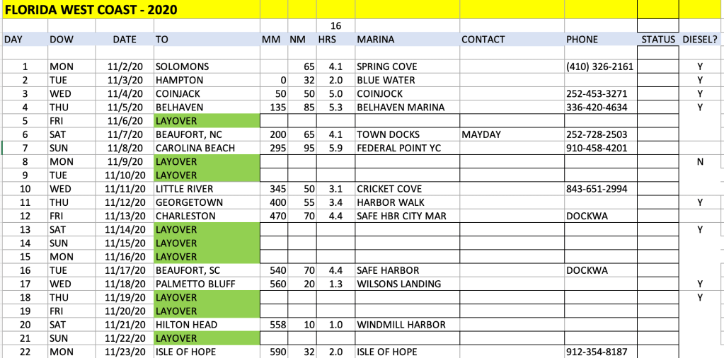
Pilots file Flight Plans. Sailors file Float Plans. Here’s the first segment of ours, built in Excel.
Here’s how we built it:
It begins in early November, because our insurance policy will not allow us to be south of Cape Hatteras until the hurricane season ends on November. 1st.
We began planning each day’s leg by looking ahead 50-80 miles to see what marinas were available.
Sometimes the legs were shorter; sometimes longer.
Then we built in our layover days: at least one per week, allowing for weather.
More layover days for fun stops like Charleston
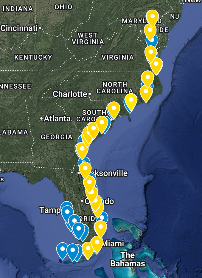
MM stands for Mile Marker. The ICW portion begins at MM 0 in Portsmouth (Hampton), VA and ends at MM 1245 in Key West.
NM stands for Nautical Miles traveled that day. This is the critical variable for planning purposes.
HRS stands for Running Time in hours at an average of 16 knots.
Based on the Float Plan, I expect the trip to take 33 days elapsed time, allowing for layover days for weather and R&R. We’ll leave 11/2 and arrive in Key West December 4th.
It’s 26 actual travel days. Not particularly daunting… just 26 days when – every day – something can possibly go wrong. Ha Ha.
Each horizontal row represents a single day-trip. Green cells are lay-by days for visiting or for rest or as a bad-weather provision. There are also yellow cells indicate opportunities to leave the ICW and travel “outside” for a speedier passage. These opportunities exist because there are inlets that are safe to navigate (many are not), but the decision to go outside is entirely weather-dependent.
For that matter, the entire schedule is entirely weather-dependent. We will take whatever steps are prudent to avoid bad weather. Rain isn’t a problem, but rough sea conditions may cause delays, particularly in places like Albemarle Sound. The Sound is only 14 miles across (less than an hour for Freedom), but it can become very choppy because it is uniformly shallow, and wind from almost any quarter can create rough, confused seas. (per Waterway Guide). In particular, if the wind is as little as 15 knots out of the west, it can make for a very unpleasant crossing. For that reason, it may be necessary to lay over an extra day or two in Coinjock to wait for better weather. We may even have to wait up in Hampton if the boats ahead of us are holding up in Coinjock. If the marinas are full, we need them to move out so that we can move in.
In that case, the entire schedule may slide. We built the same flexibility into our plans when we brought the boat down from Nantucket: Hurricane Isaias was threatening the Northeast, so we just holed up in a protected marina and let it pass. We were able to make up the lost day by skipping one scheduled stop. Something similar will undoubtedly happen on this trip.
It is critically important to make decisions according to the weather, not the calendar. It doesn’t really matter when we arrive at each intermediate stop. Reservations can usually be tweaked with no problem, or an alternative can be found. Safety and comfort come first.
Forget what I said in my last post about not trying to do day-to-day planning in advance!
Once I broke the trip into segments, it seemed much more manageable to then break those segments down into day trips. I’m sure there are folks who would set out on this trip with a minimum of pre-planning. That’s not me; I’ve always been a planner.
I’d like to get a sense of how long this trip will take, so I have to figure out how far I’ll travel each day and where I will stay each night, so that I can set up marina reservations. But one of the biggest unknowns I’m grappling with is how many miles I should plan on traveling each day. I know how fast Freedom can go, but I don’t really know what the ICW is like: is it like Interstate 95? or more like a wandering lane? I hear it’s a little bit of both.
Anyway, here’s my thought process:
Freedom has enough fuel to travel more than 200 miles per day, but that’s neither safe nor comfortable:
That would run her fuel down to ZERO – very foolhardy. In fact, it’s better (more prudent) to always “run off the top half of the tank”. So that limits us to a maximum of 100 miles per day for planning purposes.
Also, Freedom’s most efficient cruise speed is around 18 mph. At that speed, it would take almost 13 hours to cover 200 miles… exhausting when you are single-handling.
In addition, there will be slower boats ahead of us all the way. We will pass them, but to do so courteously, we have to slow down. There are also multiple “No Wake” zones, and that reduces your average speed.
For all these reasons, and based on advice we’ve received from experienced captains, we will plan to travel around 50-80 miles per day average. At an average speed of 16 mph, that’s about 5 hours per day. Perfect.
Now I can get to work roughing out a day-by-day itinerary.
Once I do that, I’ll start to get a time frame for the overall trip.
I’ve spend hundreds of dollars on charts and Waterway Guides: I have a stack of paper that’s probably 7″ high. And I’ve spent A LOT OF TIME reading about the routes we’ll follow. Plus, I get online Alerts that arrive electronically: reports of channels that have shoaled; missing navigational markers; and treacherous inlets. Most of these cautionary notes pertain to sail boats with deep draft. We draw only 4 feet.
We also have to pay attention to bridge clearances. Again, these pertain mainly to sailboats: we can pass under bridges with just 14 feet clearance, as opposed to some sailboats that have 50+ foot masts.
Nevertheless, the amount of information that one has to take in can be daunting. If I were the worrying sort, I might be hesitant about the entire trip. But hundreds of people do it every year, and I think I’m well prepared. Perhaps better prepared than many.
Still, it’s a lot to learn, and a lot to visualize. As a consequence, I’ve decided to break the trip into discrete pieces in order to make it more manageable.
++++++++++++++++++++++++++ The first “chunk” is the section in the Chesapeake Bay: from Rock Hall to Norfolk, VA, at the southernmost tip of the Bay. Once I get to Norfolk / Portsmouth, I’ll be at Mile Marker Zero, the start of the ICW.
The next chunk is a single leg, from Norfolk/Portsmouth, through the Virginia Cut, through the Great Lock, to Coinjock, Virginia. Then a long run of 68 miles across the Albemarle Sound to Bellehaven. Once I get there, I’ll have a lot of experience under my belt. Each night, I’ll carefully plan the next day’s route and check the weather. It’s simply too much to try and plan the entire trip in detail in one sitting. But if I handle it one day-trip at a time I’m confident it will minimize the inevitable exigencies that will arise.
BTW, I’m dictating these thoughts using an app called Speechify. I dictate into Speechify, copy the text into Word Press and edit the final version. So far so good, but please excuse any garbled content!
When I first started posting about my trip plans, Barbara Drennen (a cousin) asked if I had solo sailing experience. I guess the answer is no and yes.
Remember that I grew up on boats, and Cathy and I had boats our whole married life.
So, for the last 50+ years, I wasn’t saying solo; I always had someone with me – Cathy. But, she always trusted me to plan the routes and captain the boat. She was happy to help with other tasks (handling the lines, etc.) but she was happy to let me be the captain.
So for all these years, I have always felt the responsibility of command. Not to over-dramatize it, but to plan the route, make the right decisions, and get us to the next destination safely.
I believe that the MOST IMPORTANT role Cathy played was as observer – we always ensured that our boats had a seat for her right next to mine, because she was constantly on the lookout for other boats or hazards. She was also always there for advice and consultation.
The new boat, however, has increased my confidence that I can go solo: – It has auto-pilot, so that I can set a course and then spend the travel time on the lookout as Cathy used to do – The auto-pilot means driving is much less stressful – Bow and stern thrusters mean I don’t need Cathy’s help to guide Freedom into a slip. – Freedom is a heavy, well-built boat that can handle wind and waves. – And of course it has a chart plotter (GPS), depth sounder and radar.
My only real SOLO experience was bringing Freedom down alone (with Guinness, of course) from Nantucket. It took two weeks. There were several spots where we were out of the sight of land, relying entirely on instruments. We dodged a hurricane simply by holing up in a protected marina, and we became proficient at planning and executing each day’s trip. We got in and out of multiple harbors and multiple docking situations. We also encountered some very sloppy seas on Buzzards Bay, and she handled herself admirably. Not bad weather – we don’t go out in bad weather, but it often blows 25 knots on Buzzard’s Bay.
The Nantucket trip turned out to be the shakedown cruise, and it increased my confidence in the boat and my ability to handle her.
Importantly, I also realized the importance of careful planning; perhaps we’ll talk more about that in our next few posts.